In a Without Rule of Law (WROL) situation, your ability to navigate will become vital. Even if you plan on sheltering in place, you’ll need to go out for things, and traditional methods can put you at risk.
We’ve become too reliant on the convenience of GPS. Even outdoorsman now over-rely on it. It’s a great tool and we’ll discuss a couple of ways to still use it in a WROL situation, but we need other methods, because of the following two main risks:
- GPS Relies on Ground Stations – If the ground stations loose grid power, the satellites will lose their exact fix on their location and begin to drift, but still reporting out their original location. It will become unreliable over time.
- GPS can be “Shut Off” selectively – As we saw during the 2020 Virginia Second Amendment protests, the United States Government has the ability to shut down the entire system in a geographical area. Users reported GPS outages in about a 200 mile radius, and the US Navy stated that they “just happened” to be doing an exercise in which they disabled GPS that “coincided” with the protest.
Another risk of GPS over-reliance is that many people have stopped buying handheld units, preferring instead to use their cell phone as a GPS. If the power is down, cell service will go down, and with it your ability to download mapping.
The easiest one of these to fix is the need of a mobile network to download mapping. Most services allow you to download at least a small local area to your device to use when off-line. A service like Sygic, which I use, allows you to download any mapping you want and have the storage space for, so that you can use your phone as a GPS off-line.
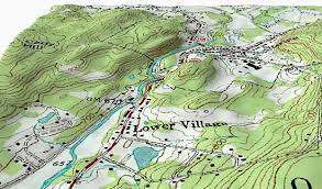
The other two can only be solved by the use of paper maps and compasses. It’s a vital outdoor and preparedness skill, and one you really should have. Buy and obtain as detailed of local maps as you can. If you live in a city, street level maps are vital and in rural areas, a combination of street maps and topographical maps are needed.
What if I don’t have a map and compass? Well, the Ultimate Tactical Handbook has some guidance on that situation:
The wise listen & add to their learning,
And let the discerning get guidance.
Proverbs 1:5
A map is guidance, but so is our next skill:
There is a skill that will enable you to still have a good idea of where you are going, even without a compass and a map. Following roads or terrain features can ensure that you stay on a particular route.
The problem is that these are known militarily as “natural lines of drift”, or areas in which humans will be moving. In a WROL situation, other people mean risk. There will be others moving along every road, path, electrical transmission line, river, and railroad.
Let’s take rivers as our example. Every major city in the world is on a river. This is because, for all of human history, we’ve been drawn to sources of fresh water, and rivers made a way to conduct trade, as well obtain food and water. Ancient hunting tribes followed rivers because game was drawn to the water as well.
Building on that in a modern setting, people will be drawn to walk away from danger along natural pathways, like rivers, highways, roads, railways, utility cleared corridors, and the like.

In order to avoid encountering other people, the US military trains patrols to do what is known as “hand railing”. Hand Railing refers to moving along a terrain feature, whether man-made or natural, by always keeping it in sight, while not actually using the feature for movement.
You can follow the path of a highway by remaining in the concealment of woods along the highway, but 100-200 meters to the side. Even in farmland, you’ll see ditches or wood-rows traversing the fields, that would allow you to remain safely concealed while moving.
In using highways to hand rail, it helps to understand how the interstate highway system operates to help navigate. There are two different systems, the US Highways and US Interstates. The rules are listed here:
- North-South Routes: On US Highways, they are numbered with odd numbers, beginning in the east, and getting higher as you move west. Interstates are also odd numbers, but with the lowest in the west, and the highest in the east.
- East-West Routes: On US Highways, they are numbered with even numbers, beginning in the north, and getting higher as you move south. Interstates are also even numbers, but with the lowest in the south, and the highest in the north.
- Spur Routes: A spur is shorter section off of the main highway, with a number in front of the two-digit main route.
As you can see, by knowing these rules and hand railing the highway, you can indeed navigate fairly well.
However, when traveling in more remote areas, you may have to hand-rail a terrain feature like a river or a railroad (maybe a power line). Avoid the temptation to travel directly along the feature, as you will surely encounter other people, some of whom will have bad intentions or just be very desperate.
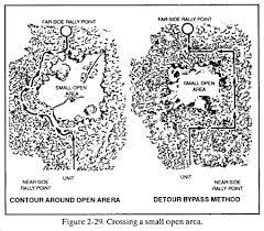
You can also hand-rail to avoid danger areas. Let’s say you are hand-railing the freeway, and come to a large area of farm land. You can travel around the farmland, hand-railing it’s edge, until you get past it, allowing you to resume hand-railing the freeway along your route.
When conducting hand railing, avoid also the temptation to camp along the same path you are hand railing on. For instance, if you are moving 100 meters west of a river, just keeping it in sight, when it comes time to camp, move another 50-100 meters away from the river before camping.
The reasoning is simple. What if another group is traveling directly along the river (or whatever other feature you’re hand railing) and they decide to camp? Rather than camp directly in danger on the feature, they’ll also want to move a distance away from it to camp, and could have blundered right into your location.
Don’t under-estimate your need to be secure in a WROL situation. You can’t possibly know the intentions or attitudes of any group you encounter, so the best strategy is to avoid contact altogether. Hand-railing and then moving another distance away to sleep is safer.
The same hand-railing rule applies to trails. Throughout most metro areas there are urban trail systems. In a WROL situation, people will flock to these for a number of reasons; to leave the area, look for firewood, set up camp, hunt, etc. Get out on these systems now and look for hand rail opportunities.
The one closest to where I live has very small game trails just off both sides, because the wildlife is trying to avoid the humans on the walking trails. I’ve done lots of experimentation and people on the trails never look too deep into the woods. You could hand rail the walking trail the entire way, and just take a knee anytime you saw someone else on the trail below.
But what about urban movement? If you’ve chosen to shelter in place, there will still be reasons you’ll need to venture out, and there will definitely be other people about, some of whom are dangerous. Is there a way to navigate in the city to avoid contact? There are several.
First, learn the local basic layout. For example, in Metro Detroit, the “mile” roads (8 Mile, etc) tell you far north of Michigan Avenue (in the City) or Cherry Hill (west suburbs) you are. The major roads are one mile apart both north-south and east-west. You need to know the basic layout in your area.
Next, learn where there are usable alleyways and where rail lines or power lines go through. These will be good terrain features to use, just remember to hand rail them rather than walking directly on them. In an urban environment, you won’t be able to move 100 meters off the feature, but can follow a woodline next to it, rather than walking in the open.
But what about the suburban sprawl without alleys or train tracks? There will always be power lines, but sometimes that isn’t enough and you’ll need to use the roads. In this situation, we’ll take advantage of human nature & laziness to be safe.
In a neighborhood, people will be looking for other people either walking in the road or on the sidewalk. This leaves you three options:
- Backyards: This is the preferred option, but fences could make travel dangerous, as could being in the backyard of a house that is occupied.
- Drains: Most maps identify urban drains, which are man-made creeks generally running between two subdivisions, leading to a larger creek or river. They make great urban movement channels.
- Front Yards: Probably the most realistic option in a WROL situation is to transit a neighborhood by walking through the yards halfway between the houses and the sidewalk. Human nature would not be looking there for people. If you spotted someone farther down the street, you could hide between houses until they passed or switch to backyards.
Transiting neighborhoods have no good options, these are just the three that are most secure. Before someone leaves a comment about what would happen if I did that in their yard, understand that we aren’t talking about TODAY, we are talking about a WROL situation. In that scenario, I’d be fine with someone walking through my yard, as long as they kept on going, and so would you.
If you live in an urban area, get out and walk now. Learn the routes into and out of the neighborhood on foot. We discuss doing this study in the soon-to-be released Base Line Training Manual, our first in a series of preparedness training books.
Get and practice hand railing at your local trail system and develop the skill. Study your local maps to find drains, rail systems, and power lines that you can use, then get out and take a look at them, visualizing how you make the movement in a safe and concealed manner.
If you’d like to support our content or the book project, you can donate below.

Donation – March 2021
Donation to produce content.
$5.00

We use the same compass!
LikeLiked by 1 person