
One of the biggest issues I’ve faced since this slow-moving collapse started last spring is verifying all the information coming in.
At the very beginning, we heard reports from all over of checkpoints at state lines, roadblocks for “COVID” checks, ID checkpoints, etc. Nearly all of it turned out to be rumors and none of it could be independently verified.
In this post, we’re going to discuss some tools and formats to help your team learn to gather & report information properly, how to research what you receive, and the standard NATO matrix for evaluating information.
I know, for a lot of you, this is review. But review never hurts. Also, I know a lot of you imagine that in the SHTF world, you’ll be some kind of high-speed operator the likes of which we haven’t seen since Mad Max Rockatansky patrolled the outback for the Main Force Patrol (bonus points if you get the reference).
However, in a world gone dark or a world in conflict, INFORMATION is the key to survival.
From the Ultimate Tactical Handbook:
Then Joshua secretly sent two spies…
“Go, look over the land”, he said, “especially Jericho”
Joshua 2:1
Sending out a team to look at the land, spot the opposition, etc, is as old as humanity itself. What’s more important that just telling them to go look is to tell them EXACTLY what you want them to look at and how they should report it. That’s where reporting formats come in.

A great tool to ensure accurate reporting is an App called Solocator. It’s a camera and GPS function that gives a date/time/location stamp on any photo. It will work without a cell signal, as long as the phone is receiving a GPS signal.
I used this when all of the news videos without date and time stamps came out, allegedly showing overwhelmed emergency rooms, and lines out the doors. I simply drove to several metro Detroit ER’s and took photos with the Solocator app, proving that there were not actual lines or crowds.

The first format is SALUTE. It’s an acronym meaning Size, Activity, Location, Unit (or uniform), Time, and Equipment.
Let’s say I was watching for an ANTIFA security team to get set up at a planned protest (yes, they do, about an hour before). An example of a SALUTE report of their arrival would be: “4 personnel, securing a perimeter with tape, corner of Any Street and Loser Parkway, all wearing black clothing with yellow bandanas on the left arm, 2:30 PM today, each had a BaoFeng BF 888 radio, one had a sidearm, unknown model”.
As you can see, it’s far more accurate & concise than “some ANTIFA guys just showed up”.
The format works for anything you want someone to report.

I use my BattleBoard Scout Small (www.battleboard.us) to help me gather the information for a SALUTE report, and this reference card inside the polycarbonate window (see photo above) allows me to write the information directly on the window with a dry erase, and then I can transfer it to something more permanent after getting down the urgent data.
In a fluid situation, sometimes only SALT is reported rapidly, for everyone in your group’s situational awareness. Knowing immediately the Size/Activity/Location/Time of a potential adversary near your location is vital, other things can be developed later.
While your current situation or SOP will dictate how the information is reported originally, It should always be reduced to a written form,, for retention and use later. Something that appears irrelevant today, can suddenly become vital next week, if you had the information at hand. You can also review weekly trends and in a true SHTF situation, your reporting review may show that the local RevCom group slides through the area every Wednesday afternoon. That’s usable intelligence.
Even if a report is transmitted via radio, eventually reduce it to paper and retain it. When this first began, a group us began have a nightly information sharing session via radio. I took down all the information reported and began seeing trends in National Guard movements, police activity, and food shortages, that have helped me plan in this second round of shutdowns.
Patrol reporting is just as important as well. Let’s say you didn’t send a team out to look at something specific, just to take a stroll around your perimeter and see what’s happening outside your gate. While they should transmit back or record any SALUTE reports they generate, they should also document people they encounter, vehicles they see, any activity on-going. The easiest way is for them to write this down while conducting the patrol, documenting the date/time/location of every observation.
Again, the BattleBoard Scout is a great medium for this. Inside the Scout, it holds a Rite in The Rain (www.riteintherain.com) Tactical Notebook, that will allow you to take notes regardless of the weather and it’s a very sturdy product.
Once the patrol returns, they can reduce the notes to a written patrol report, which should again be saved for analysis. You don’t know what will become relevant later. A vehicle seen once on patrol, arrives at the gate 3 weeks later and tries to force their way in. Would you rather try to remember the license plate & description from 3 week old memory, or have it already written down so that everyone can watch for it?
An example of this is when I began my ANTIFA observation project this spring, sometimes, rather than joining their march, I just recorded vehicle description and license plate data. Within a few days, I was able to identify the organizers and security team because the same vehicles appeared all over the region, a short time before each planned protest.
Standardize your patrol report format. A simple format is a short narrative describing the route and what was encountered, followed by a listing of people/groups encountered and vehicles encountered. It’s that simple, and you’ll be able to quickly review it all.

Another tool is sketching. Sketching is simply drawing out a representation of what you are looking at. It doesn’t have to be museum quality, but it does need to be somewhat representative of what was seen, so that it can be used.

There are 3 types of sketches for our purposes. The first is “Panoramic”, where you are just drawing what you see while looking forward from your position. The second is “Topographic”, which is like an overhead view, where you are essentially drawing a map of what you see. For the record, most military scouting requires BOTH sketches. The third type is “Range Card”, which is essentially a mix of the two with ranges to all landmarks, but range cards are a topic for another time.

Every sketch needs to contain the location where the observer was, the date and time it was made, and a graphical direction indicator. You can indicate which direction is north, which direction the observer was facing, or both (both is best). It’s also not a bad idea to jot down the weather conditions at the time of the sketch.
Now we are on to the topic of evaluating information or validating it. The best way to validate information is to just go to the location and look for yourself.
In a true SHTF/WROL situation, that may involve sending out a more substantial, planned scouting team to specifically investigate a location.
Right now, in the weird semi-SHTF situation we’re in, it can involve jumping in a car, driving out to the location and taking a look, recording your observations.
If one person saw it, it’s just information. If someone saw it, then a second team validated it, it’s intelligence.
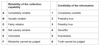
Most often, though, you will be getting information third hand, whether it’s from a neighboring preparedness group, refugees passing through, or other human sources. You can use the above NATO Matrix for assigning a value to the information that comes in. This allows you to prioritize your scouting efforts on the most likely information.
In our current situation, the best thing we can do is to STOP re-sharing information that we cannot validate. The internet is full of unfounded rumors from the plausible to the highly unlikely, yet strangely commonly believed. You can find information supporting whatever crazy snippet of information, but that is not the same as VERIFICATION.
So often, people share something and when you ask them for a source or verification, they say something like “I don’t know, but I’ve seen it from multiple sources”. The truth is they’ve seen THE SAME INFORMATION multiple times, but not from MULTIPLE SOURCES. Two different people sharing the same meme isn’t multiple sources.
When you see something, use multiple search engines to try and verify the information. If the searches all point you to the same picture or meme, it’s unconfirmed. If you find a reference to a press release, or multiple news stories, then you may have found confirmation.
Don’t turn around then and just share the original item, share what YOU VERIFIED. Better yet, just keep the information yourself.
I hope this information helps you and your preparedness group gather and evaluate information.
Check out contact page if you’d like some personal consultation or if you’d like to donate to help me continue to produce great content.
Donation
Donate if you’d like to help us continue to produce great content.
$5.00

Glad to see you have the ability for people to donate to you rather than just taking your VITAL info for free without a way to pay for it. Just sent my first of what should be quite a few beers worth of donations.
One thing I did want to note: the app you mentioned you said could be used without a signal as long as it has GPS. I spend the money to get (at least as far as my ADD grade research will take me) the best devices on the market. The latest ones have needed cellular data for the GPS to work. So that might be a potential weakness in relying on that system.
Just thought I’d point that out, as someone who just went thru that in a road trip scenario.
LikeLiked by 2 people
Thanks Bacon!
LikeLiked by 1 person